Enregistrez gratuitement cette image
en 800 pixels pour usage maquette
(click droit, Enregistrer l'image sous...)
|
|
Réf : T01445
Thème :
Terre vue de l'espace - Mers - Côtes - Caps - Péninsules (601 images)
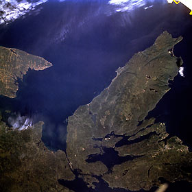
Titre : Cape Breton Island, Nova Scotia, Canada September 1992
Description : (La description de cette image n'existe qu'en anglais)
The Canadian maritime province of Nova Scotia can be divided into two separate regions—Cape Breton Island and much larger, peninsular mainland Nova Scotia. Cape Breton Island is joined to the mainland by a causeway and a railroad spanning the narrow Strait of Canso. The small scale of this photograph helps to reveal the fragmented nature and the remoteness of the heavily forested landscape in the northeastern part of Nova Scotia. The Cape Breton Highlands on the larger peninsula that juts into the Gulf of St. Lawrence consist of steep cliffs and a rugged coastline, forming some of the most spectacular scenery in northeastern North America. St. George’s Bay is the small bay west of the causeway, and the Northumberland Strait separates Cape Breton Island from the eastern end of Prince Edward Island, another maritime province of Canada (visible along the west margin of the photograph). Chedabucto Bay is the small bay east of the causeway bridges. Bras d’Or Lake is the large body of water in south-central Cape Breton Island, and St. Andrews Channel is the elongated, northeast-southwest-oriented water body north of Bras d’Or Lake. Cape Breton Island is noted for its superb fishing industry, coal mining operations around the city of Sydney, and its tourism industry. The port city of Sydney is visible along a highly reflective inverted Y-shaped inlet near the southeastern edge of the photograph.
|
|

